Research
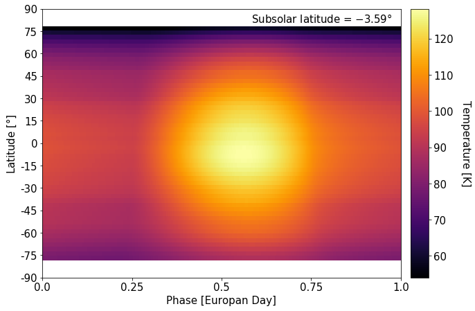
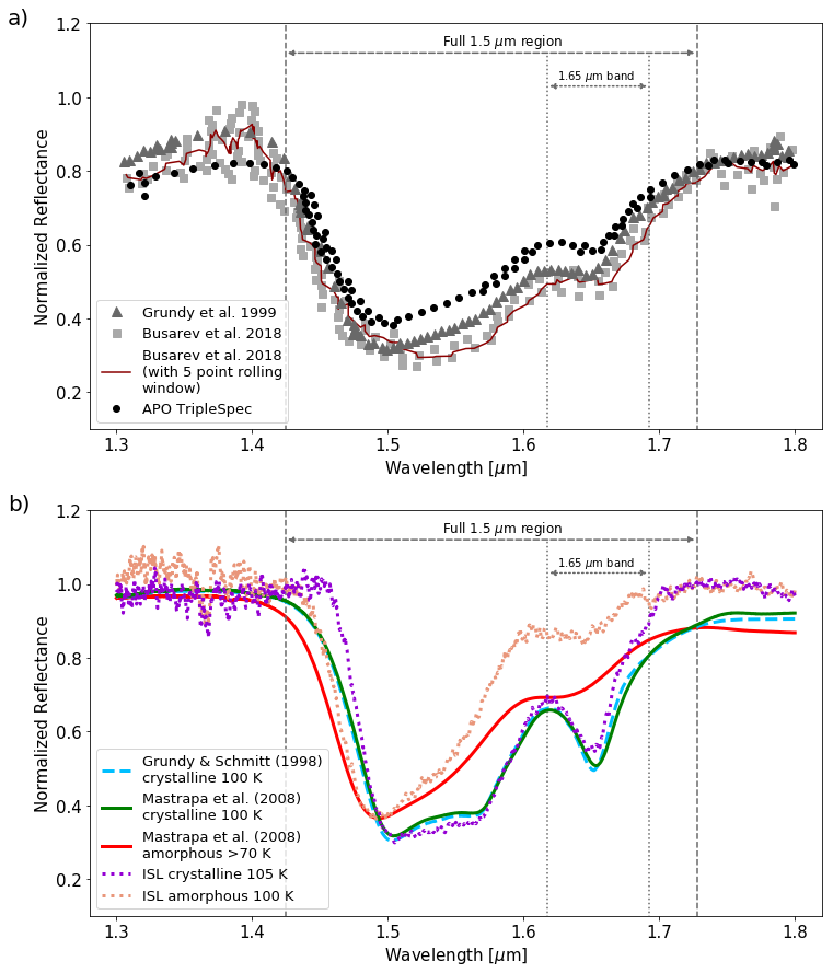
I am currently working on my thesis/dissertation project to investigate crystalline and amorphous water ice on Europa. I am analyzing near-infrared spectroscopic data, particularly near the notable water ice bands, 1.5 and 1.65 μm, in an effort to constrain the physical and geomorphological processes that currently affect (or have affected in the past) the surface of Europa. I am using imaging spectroscopy observations from the Galileo Near-Infrared Mapping Spectrometer (NIMS) instrument, ground-based observations from the Apache Point Observatory, and laboratory spectra from the NASA Jet Propulsion Laboratory Ice Spectroscopy Laboratory obtained with my NASA Technical Advisor, Dr. Murthy Gudipati. I will identify whether the crystallinity (i.e., the content of crystalline water ice compared to the combined content of amorphous and crystalline water ice) that we observe from ground-based spectra differs significantly from the crystallinity we expect to see based on laboratory data, temperature modeling, and radiation flux. The main result of this work was that the crystalline-to-amorphous water ice fraction observed on Europa’s leading hemisphere cannot be reproduced by thermophysical and particle flux modeling alone (Berdis et al. 2020, Icarus, 341, 113660). In order to probe the source of this discrepancy, I am analyzing the crystallinity of specific regions-of-interest (such as lineae, pits and domes, and chaos terrain) on Europa’s leading hemisphere. I plan to speculate upon the origin of these features based on their crystallinities, and evaluate their surface emplacement into our understanding of Europa’s leading hemisphere surface history and crystallinity.
Prior to working on my dissertation project, I explored water vapor abundances in Mars' atmosphere near several of the craters that recently showed signs of hydrated salts in the form of recurring slope lineae (RSLs). These RSLs appear during local spring and summer on downward slopes, and have been linked to the evaporation of liquid water which leaves behind streaks of briny material. I am using data from the Viking Orbiters 1 & 2 MAWD (Mars Atmospheric Water Detector) and IRTM (Infrared Thermal Mapper), as well as the MGS (Mars Global Surveyor) TES (Thermal Emission Spectrometer) to track the evaporative supply of water vapor in the atmosphere. See animated GIFs of spatial and temporal distribution of water vapor abundance for Hale Crater, Horowitz Crater, Palikir Crater, and Coprates Chasma. I have thus far successfully identified a strong correlation between surface temperature and water vapor abundances, and I have determined approximate average water vapor abundances (in precipitable microns) within each location at specific time intervals throughout the Martian year. Measurements from the Mars Reconnaissance Orbiter (MRO) Mars Climate Sounder (MCS) instrument will also be included in this assessment. Additionally, I will use a General Circulation Model (GCM) of Mars' atmosphere to determine the amount of surface water required to supply the minimally detectable water abundance signals in the MAWD and TES measurements. This will aid in the assessment of any measured water vapor signals potentially connected to RSL formation. The result could reveal the origin of water vapor, and could provide constraints on the amount of surface water that originally caused the RSLs. Additionally, the amount of detectable water could put constraints on the capabilities of the recently launched ExoMars Trace Gas Orbiter to detect water released by RSLs.
During the fall of 2015, I worked with Dr. Moire Prescott to create line ratio plots from spectroscopic data of a Lyman-alpha nebula at redshift ~1.67. The resulting code takes input FITS files for different line profiles, computes signal ratios and errors, produces a line ratio profile with respect to position along the slit, and outputs a .txt file of all signal/error data used for the profiles.