The Development of Geology as a Science in the Seventeenth and Early Eighteenth Centuries
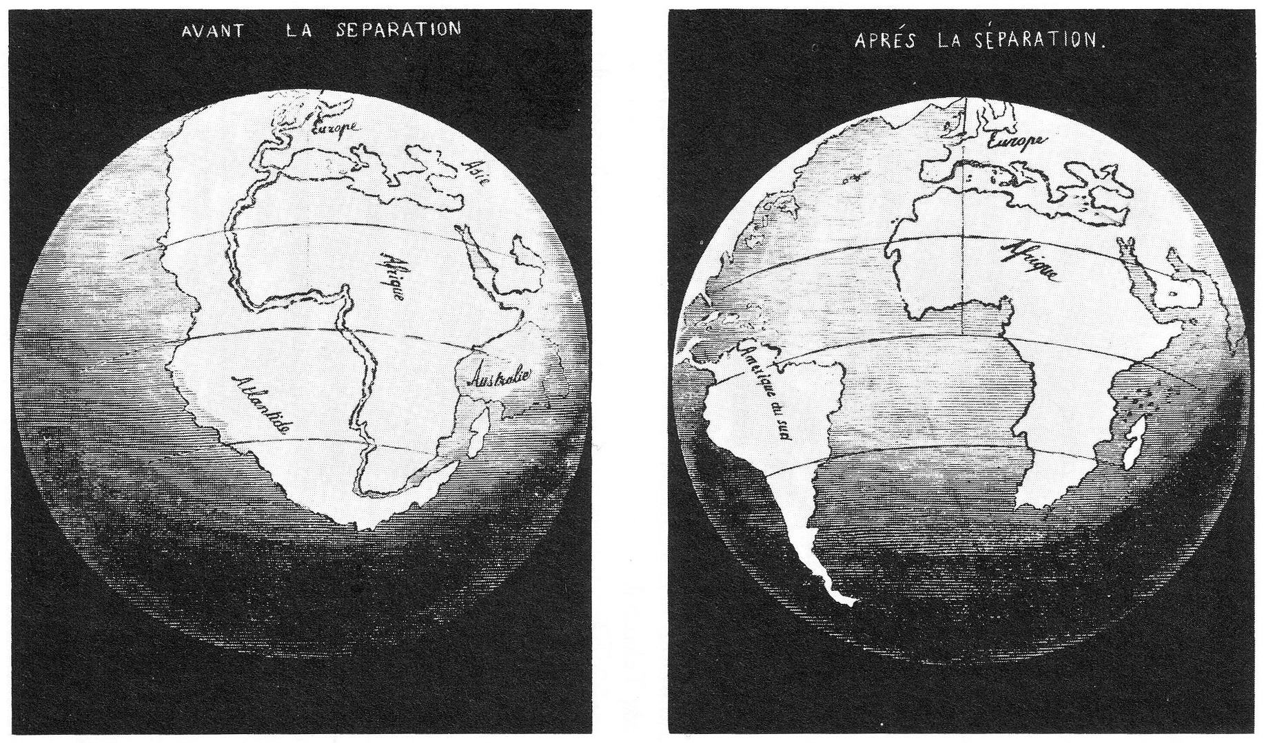
The 15th and 16th centuries are now well known for the various great explorations, from Columbus to Magellan. During this era, the first maps of the globe were being constructed. It did not take too long to recognize that the continents as drawn on these maps had boundries that kind of fit together. The first person to realize this appears to be Abraham Ortelius (1527-1598), a Dutch map maker, who suggested in 1596 that the "Americas were torn away from Europe and Africa by earthquakes and floods". Francis Bacon noted this same thing in 1620. This lead to the idea that once upon a time, all of the continents were joined together, and some catastrophic event must have split them up. Most believed that some sort of biblical event, such as the "Flood" was responsible for this splitting.
Serious discussion of this idea, in a scientific framework, would not reappear again until the 20th century.
"Until the time of Nicholas Steno (1638-1686), most advances in geological knowledge were in the fields of mineralogy and mining. Steno studied rocks in the field in a broad geological way and used direct observation to enable him to reach a number of useful conclusions.
Particular aspects of sedimentation had been recognised earlier but Steno was the first to state important principles about layers of sedimentary rock. He illustrated his theories with diagrams showing the geological history of Tuscany. He divided the history into six phases and believed, wrongly, that the six phases were of worldwide application.
In the Eighteenth Century it became popular among men of culture to record their findings in the natural sciences. The succession of rocks in the coalfields of England became well documented and it was believed to apply over a much wider area. In 1719 and 1725 John Strachey published two interesting illustrated papers showing the order of rocks in south-west England. He pointed out that, although the coal strata were all more or less inclined, the overlying rocks lay horizontally across them.
Elsewhere in Europe the first real attempts to apply systematic subdivisions to the rocks were made by Giovanni Arduino (1714-1795) in Italy, Johann Lehmann (1719-1767) in Germany and Peter Pallas (1741-1811) in Russia. Arduino classified the rocks of Northern Italy into Primitive, Secondary, Tertiary and Volcanic. His classification was based on the appearance of the rocks and on the occurrence of fossils.
Lehmann in 1756 distinguished three orders of mountains:
(a) Those he believed to have been formed when the
world was made;
(b) Those formed from sediment deposited in sheets
under water;
(c) Volcanic mountains.
Lehmann's work was followed by that of George Fuchsel (1722-1773) who published in 1762 one of the first geological maps in his book 'A History of the Earth and the Sea, Based on a History of the Mountains of Thurinqia'.
Pallas, in Russia, recognised three broad divisions of mountains and rock groups. He saw that there was clear evidence of the presence of the sea in former time in some areas and supposed that the elevation of the mountains was caused by uplift during what he termed "commotions of the globe".4
Clearly, observation was now playing a much more important role in understanding geophysical events, and geology was becoming a real science:
"Development of geology as a separate branch of science took place in the years between 1775 and 1830. Geologists commemorate 1775 as the year in which, at a small mining academy at Freiburg in Germany, geology was first taught by Abraham Werner. Charles Lyell published the classic textbook, 'Principles of Geology', in 1830-1833. Many basic principles of geology were recognized and described during this period. Particularly important were those set out by James Hutton in Scotland. Two other writers of note were William Smith in England and Georges Curvier in France.
Abraham Werner (1749-1817) was a careful mineralogist who drew up an excellent system of classification of minerals based on their properties. He did not travel extensively, but based most of his geological ideas on the small region around Freiburg with which he was familiar. Unlike many present-day scientists, Werner published few of his theories but the ideas presented in his popular lectures were soon spread throughout Europe by the enthusiasm of his students.
Werner held that rocks such as granite had formed during the earth's early history by crystallization in a worldwide ocean. He concluded therefore that the oldest rocks in any region were granites and other crystalline rocks. He did not believe that volcanoes were important in past geological eras. Because of his theory that what are known today as igneous rocks originated in the sea, Werner and his followers were called 'Neptunists'.
James Hutton (1726-1797) must be regarded as the "father of modern geology". A medical graduate of Edinburgh University, Hutton inherited a comfortable income and took up farming. He spent a great deal of time examining interesting rock outcrops in Scotland and Northern England, and presented his ideas to the Royal Society of Edinburgh in 1785 in a paper entitled "Theory of The earth". The Royal Society of Edinburgh was at that time the most active scientific body in the world.
Hutton recognised the importance of unconformities and pointed out that many igneous rocks clearly intruded surrounding rocks, and therefore were younger. Because Hutton and his followers held that igneous rocks came from molten material within the earth, they were called 'Plutonists'. His friend, the mathematician John Playfair (1748-1819) publicised Hutton's theories and added further ideas.
Hutton's most important concept was that of uniformity - the idea that processes active today were also active in the past, and thus that all geological phenomena can be understood in the light of present processes."4
After the development of radiometric dating (see below), the concept of uniformity, and stratiography came into their own. Go here for more on the development of modern geological techniques, including the dating of fossils, etc.
The Age of the Earth
Hutton's idea of uniformitarianism, "The present is the key to the past", replaced the earlier ideas of catastrophism, the idea that all events were caused by a single, or even series, of catastrophies. But note that if processes are uniform, then we should be able to measure their rates and estimate the age of geological features, and perhaps, the age of the Earth. We deviate for a moment from our main subject to discuss early inferences for the age of the Earth. Note that one of the essential ingredients in comprehending geological processes is the understanding of how slowly they occur, and the great amount of time that has passed to allow them to "work their magic" to create what we see now.
Just about all societies had a creation myth that described the formation of Earth and of mankind. That there is a definite beginning. But some societies postulate a cyclical behavior for time. That is, that there are multiple beginnings and ends. Both Hindus and Buddhists believe in cycles for both the universe, as well as for life. Even Plato postulated that there is a 72,000 year cycle, 36,000 years of the "golden age", and 36,000 years of chaos and destruction. But Judaism, Islam and Christianity adopt a "linear time" view, one that postulates a beginning, and possibly an end of time.
But when did we get the first estimates for the age of the Earth? We do not get any clear examples of ancient peoples attempting to calculate the age of the Earth from some logical chain of events or processes. With the dominance of Christian thought throughout the west, however, by the start of the 19th century, numerous estimates of the age of the Earth existed. The most famous was that by Achbishop Usher of Ireland in 1654. He used the genealogy of the characters in the Bible to estimate that the Earth was 6000 years old, and that the Earth was created on October 26, 4004 BC, 9:00 am. Other, similar results were obtained by various writers:
"He reasoned as follows:
What Halley's work accomplished was to make the idea of the Earth having a physical history greater than human history but not infinitely old [which would be] philosophically [un]acceptable."5
George-Louis Leclerc Buffon "was convinced of the Earth's antiquity from his geological studies.
What makes Buffon's estimate stand out is that
he not only posited a physical process that required a finite time to occur
(the time for the Earth to cool from a hot molten state), but performed
experiments designed to help him make the best possible estimates. This
is solid scientific practice. "5
James Hutton, "Author of the Theory of the Earth (1795), a textbook which was one of the foundations of modern geology.
Thus, while Hutton is credited with having introduced the idea of "deep time", an age for the Earth far older than human history, he was also to deny that one could read that history in the Earth! 5
Lord Kelvin: "In the 1890s, the British physicist Lord Kelvin refined Buffon's calculation, and derived an age of 20-40 Million years. This turns out to be an underestimate because natural radioactivity in rocks helps keep the Earth warmer that it would be in the absence of any other sources of heat."5
Thus we see that by the end of the 19th century, the concept of an extremely old age for the Earth was on the rise. But it would take a lot more science over the next decade to understand the true age of the Earth.
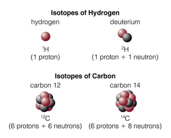
Before we discuss radiometric dating techniques, and finding the true age of the Earth, we must discuss the atom, specifically the nucleus. All matter that you are familiar with is made-up of three sub-atomic particles: electrons, protons, and neutrons. Electrons have a negative charge (-1), protons have a positive charge (+1), and neutrons have no charge. Protons and neutrons have a similar mass, about 1.6 x 10⁻²⁴ gm, while electrons have much smaller masses: 9.1 X 10⁻²⁸ gm. A proton therefore has 1836 times the mass of an electron. We can imagine the atom as a mini-solar system, with a nucleus (the Sun) orbited by a bunch of electrons (the planets). It is the opposite charges of the electron and proton that keep the electrons in their orbits, and give the elements their various chemical properties. For now, we will ignore the electron and talk about the nucleus. You have surely seen a periodic table of the elements:

This table is arranged by the number of protons found in the nucleus. For example, Hydrogen has a single proton, while gold ("Au") has 79. Along with these protons, however, are a bunch of neutrons. For example, Helium has two protons and two neutrons. Most other elements have extra neutrons. The protons and neutrons stay bound together in a nucleus due to the strong nuclear force. This is an incredibly strong force (1036 times gravity!), but has very limited range: 10-15m, about the size of a nucleus. There are specific rules on building nuclei, and the numbers you see in the periodic table are with respect to the composition of the "normal" nucleus for each element. But there is enough excess strong force that sometimes an extra neutron or two can be found in most elements. For example, Hydrogen and Carbon:
Now we have the background to discuss the history of the technique eventually used by geologists to determine ages: radiometric dating.
"On March 1, 1896, Henry Becquerel made one of the most important discoveries of our time by accident. Becquerel put a couple of photographic plates that were completely sealed in paper in a drawer next to a rock, identified as uranium ore, and left them there. After a few days, he developed the plates and discovered strange bright spots . Becquerel discovered that uranium gives off invisible rays. Although we cannot see these rays, they will cause photographic materials to react, just as visible light causes film to be exposed. The invisible rays from the uranium ore were able to pass directly through paper and cause the bright spots that formed on Becquerel's photographic plate. Materials that give off such invisible rays are said to be radioactive ."2
Becquerel made his discovery just one year after the German Physicist Roentgen had discovered the "X-ray" , a new form of high energy light that could penetrate through a variety of materials. Within a few years, Pierre and Marie Curie had conducted experiments to show that the radioactive decay of uranium produced x-rays, and had termed the phenomenon "radioactivity" . They also found that the result of radioactive decay was a daughter element. For example, through decay, uranium turned into lead. Other elements were found to have other final isotopic daughter products:
Radioactive Parent |
Stable Daughter |
|---|---|
Potassium 40 |
Argon 40 |
Rubidium 87 | Strontium 87 |
Thorium 232 | Lead 208 |
Uranium 235 | Lead 207 |
Uranium 238 | Lead 206 |
Carbon 14 | Nitrogen 14 |
[Note there is another kind of decay that does not emit neutrons, called "Beta decay". In this process a neutron turns into a proton. That is what is going on in Carbon 14.]
At the turn of the century, Ernest Rutherford was experimenting with radioactivity and discovered that specific radioactive elements had a constant decay rate. That is, over time, the total radioactivity of an element (like uranium) decreases. Some elements had faster decay rates than others:
Radioactive Parent |
Stable Daughter |
Half life |
|---|---|---|
Potassium 40 |
Argon 40 |
1.25 billion yrs |
Rubidium 87 | Strontium 87 | 48.8 billion yrs |
Thorium 232 | Lead 208 | 14 billion years |
Uranium 235 | Lead 207 | 704 million years |
Uranium 238 | Lead 206 | 4.47 billion years |
Carbon 14 | Nitrogen 14 | 5730 years |
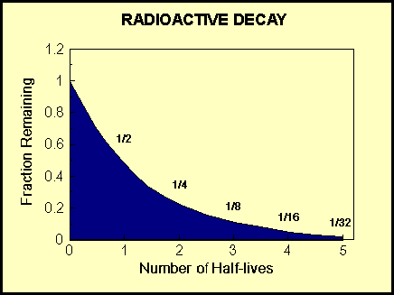
The decay in the numbers of the parent, and the growth in the daughter element can be shown in the following graph4:
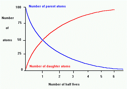
The half-life that is used to measure radioactive decay is the time it takes for half of the sample (say pure uranium) to turn in to its daughter product (say lead):
In 1907 Yale Physicist B. B. Boltwood came up with
the brilliant idea that the measuring of the fractional composition of
radioactive
elements in rock samples/layers could give you their ages! He quickly proceeded
to estimate
an age for the Earth using this technique, and derived an answer of 2.2
billion years. More than a factor of 10 times older than other estimates at
that time.
1http://www-groups.dcs.st-and.ac.uk/~history/Mathematicians/Eratosthenes.html
2 http://www.univie.ac.at/Wissenschaftstheorie/heat/heat-1/heat101f.htm
3http://www.ucmp.berkeley.edu/history/steno.html
4http://www.minerals.nsw.gov.au/minfacts/60.htm
5http://www-astronomy.mps.ohio-state.edu/~pogge/Ast161/Unit5/deeptime.html
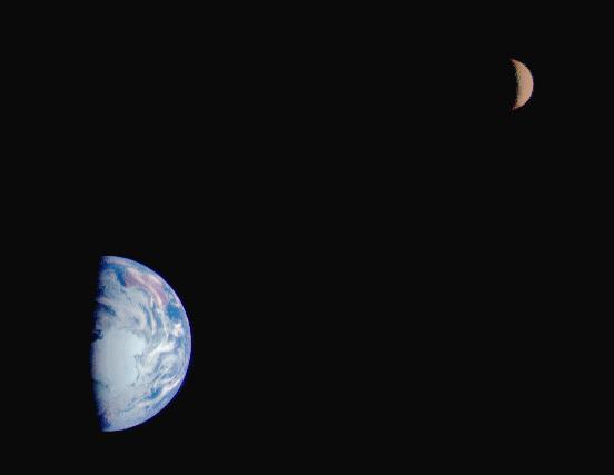
Let's begin a closer examination of the Earth and the Moon. We have learned that the Moon
orbits around the Earth on a (almost) monthly basis. First, let's talk some
numbers. The equatorial radius of the Earth is 6,378 km, while the Moon
has a radius of 1,738 km. The volume of a sphere is 4piR3/3,
thus the Earth has 49 times the volume of the Moon. If the densities of
the Earth and Moon were identical (they are not), the Earth would be 49
times more massive. In fact, the mass of the Earth is 5.97 X 1024 kg,
and the mass of the Moon is 7.35 X 10²² kg. The Earth is 81 times
more massive than the Moon, thus the Earth is 81/49 = 1.7 times more dense.
The Moon is quite insignificant when compared directly to the Earth, but
we will learn that the Moon is a significant solar system body in its own rite.
You might wonder why I bring up the subject of density--it is density which
allows you to examine the composition of a planet. Remember that density
is simply Mass divided by Volume. The units of density are normally expressed
as grams per cubic centimeter (or sometimes as kg per cubic meter). Water has
a density of 1 gram per cubic centimeter (the definition!). Using the
numbers above, we find that the density of the Earth is 5.5
grams/cm3. As you know from common experience, rock is denser than
water and does not float! Most rocks on the surface of the Earth are
silicates, that is they contain mostly silicon and other elements (such as
oxygen) . The density of pure silicon is 2.3 gm/cm3. The
mean density of the Earth is higher than this, so it must have something
heavier below its surface--hmmm, maybe iron? The density of iron is 7.7 gm/cm3.
Thus, the mean density of the Earth is just about halfway between pure silicon
and pure iron. Where is all of this iron? Well some of it is on the surface,
as we have iron-rich deposits that are mined for everyday uses. The
rest lies below the Earth's surface.
Through the analysis of earthquakes (see page 257 of the text),
we can probe the inside of the Earth:
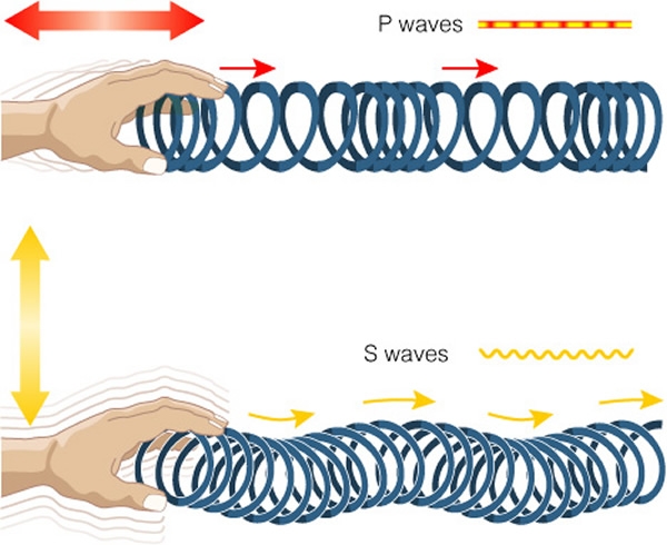
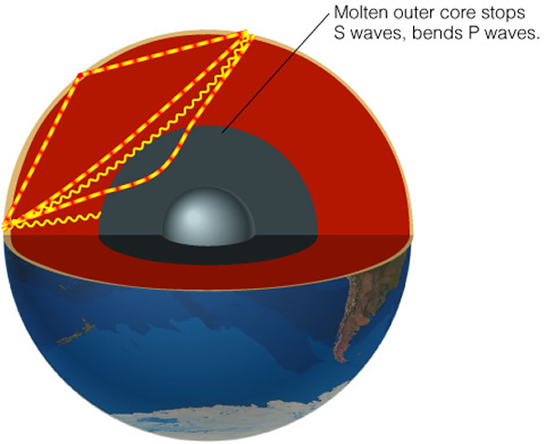
The speeds and directions at which these waves travel allows us to probe the composition, density, pressure, temperature, and whether the region is liquid or solid (the instrument used to detect these vibrations is a seismograph).
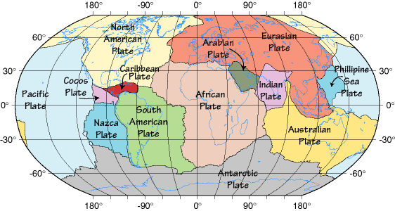
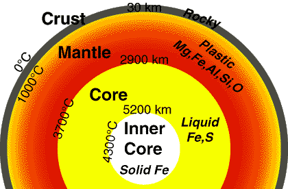
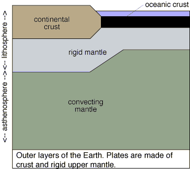
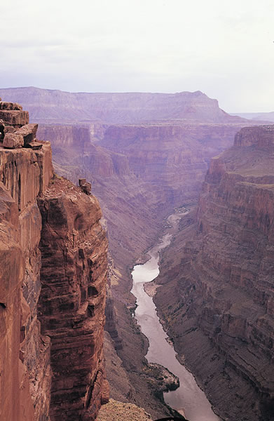
Using these techniques, we now have a picture of the structure of the Earth. The thin, outermost layer of the Earth is called the "crust". The crust is very thin, between 6 and 70 km thick. Note that the equatorial radius of the Earth is 6378 km, so the crust represents less than 1% of the radius of the Earth--it is truly just a "skin". The crust is cold and brittle, and thus can fracture (causing earthquakes). The crust is made up of large slabs of rock called "plates":
There are two types of crust/plate material, "Continental" and "Oceanic". The oceanic material is denser because it formed from volcanic material. It is also younger (the oldest parts are only 200 Myr old), and thinner (about 6 to 10 km thick). The continental crust is older (up to 3.5 billion years old), and thicker (35 to 70km). Below the crust is the mantle. The mantle is about 2,900 km thick. The upper parts are solid, while the lowest parts are "plastic-like" and can flow. Hotter portions of the mantle can rise up towards the surface where they cool and then sink back towards the center.
Below the mantle is the "core". There are two parts to the core, an outer liquid region where the temperature is about 4000o, and an inner region where the extreme pressures force the liquid to act like a solid:
The top-most layers of the Earth, that include both the crust, and the solid part of the mantle are called the lithosphere:
In the mantle, convective motions ("boiling") appear to move material around, and this motion helps drive the plate tectonics, the process that pushes the continents around the planet. For example, where hotter material rises to the lithosphere, pressure is exerted, and magma is forced to the surface causing the spreading seen in the ocean floor. Alternatively, where the mantle material is sinking, it can drag crustal material downwards ("slab pull"), causing an oceanic trench, and pulling the plates toward this subduction zone:
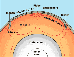
Both slab pull and upward ridge pressure act together to drive the continental drift. The welling-up of material at the mid-oceanic ridge, shown here,
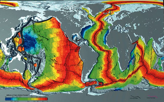
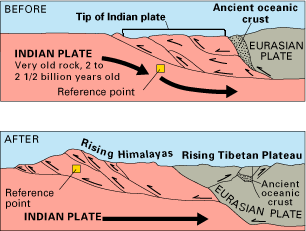
is the main driver for the drift of the plates. This continental drift creates mountain ranges, and is responsible for most earthquakes and volcanoes on the Earth. One example is the creation of the Himalayas by the force of the India plate running into the Eurasian plate over the last 70 million years:
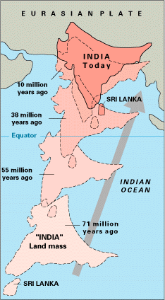
The pressure of this collision compresses part of the crust of the Indian plate, causing it to rise up to form the Himalayas. As the Indian plate is subducted below the larger, more massive Eurasian plate, parts of the Eurasian plate are up-lifted to form the Tibetan plateau:
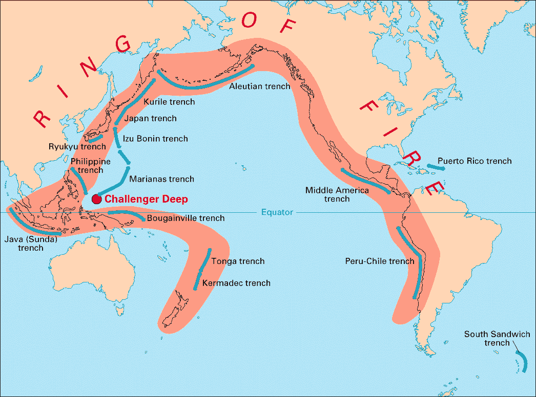
Where the North American plate is colliding with the Pacific Plate, and where the Pacific plate collides, and is subducted under the Eurasian plate, we have the northern portion of the famous "ring of fire", a nearly continuous zone of sesimic and volcanic activity:
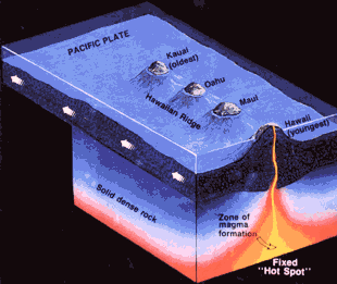
In other places, apparently fixed "hot spots" in the mantle exist, and here hotter material can reach the surface creating an island chain like Hawaii:
Where does all of this heat come from? It is not clear exactly why the core of the Earth remains so hot (to understand how we know something about the Earth's core, go here). Evidence suggests that the tectonic plates are becoming thicker, this is evidence that the Earth is cooling. Most of the heat we see at the center of the Earth comes from the earliest history of the Earth, when the entire planet was molten rock. So, much of the heat at the center of the Earth is left over from the time of formation. As bodies collided with the young Earth, they added energy. The increase in mass caused by the accretion of these objects, increases the pressure, and generates more heat. In addition, radioactive decay in the center adds heat. Because rock is a good insulator (it doesn't conduct heat well), this heat remains trapped (a more technical treatise on this subject can be found here, while section 9.1 of our text describes the heating and cooling process).
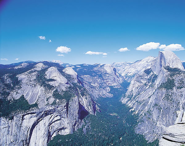
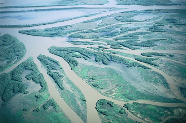
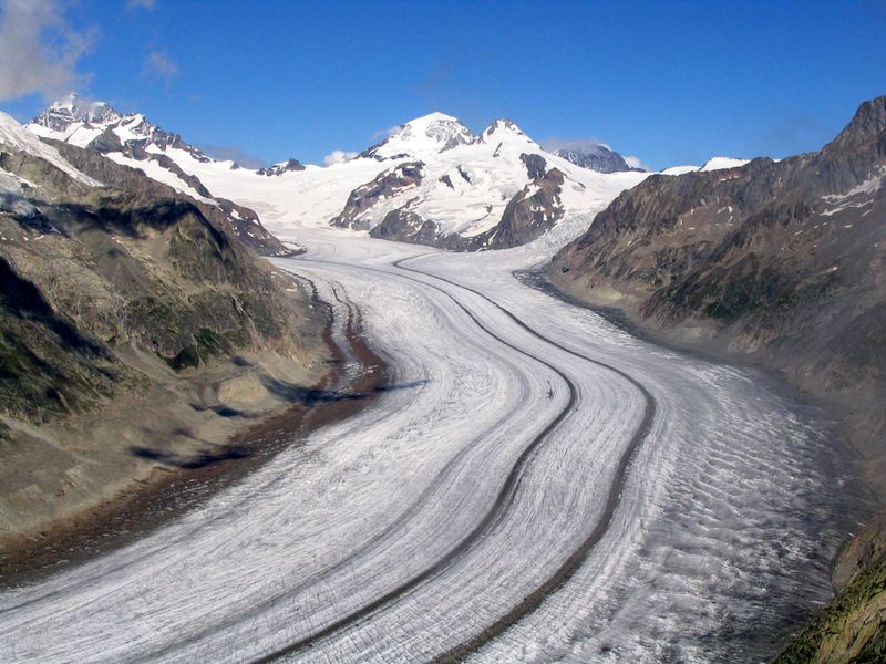
Plate tectonics and volcanic activity shape the surface of the Earth. Mountains are pushed up where plates collide, while some crust is recycled into the mantle. Thus new geological features are constantly appearing on the planet, while others disappear. For example, a large volcano can spew out lava and ash and bury valleys and lakes. This constant recycling of the surface is one reason why the Earth's appearance differs from the other rocky ("terrestrial") planets. The other major force changing the surface of the planet is erosion from water and/or ice (i.e., glaciers), wind and rain:
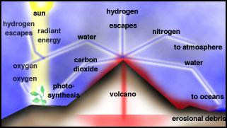
Shortly after the Earth formed and began to cool, it was likely that the Earth had no atmosphere. Our modern-day atmosphere is believed to be due to "outgassing" from volcanoes, and possibly from the bombardment by comets (which are composed of various frozen gases). The early atmosphere was probably dominated by water vapor, nitrogen, and carbon dioxide--with properties more similar to the present day atmospheres on Venus and Mars. There was very little free oxygen. The condensation of the water vapor formed the oceans, and photosynthesis by plants created the oxygen:
The composition of the Earth's atmosphere is quite unusual compared to the other planets. It is about 78% nitrogen, 21% oxygen. The remaining trace elements/molecules are argon (< 1%), water vapor (0 to 7%: altitude dependent), ozone (<0.01%), and carbon dioxide (<0.1%). The water in the lakes, rivers and oceans on the surface evaporates due to the heat from the Sun, rises, cools and condenses to fall as rain:
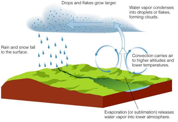
This is the "water cycle", and is important in erosion process on the Earth (as well as for our growing of food!). On Saturn's moon Titan, a similar cycle appears to operate, but there it is so cold (-178C = -289F), that methane ("natural gas") is the liquid that condenses and falls as "rain". The temperature profile of the Earth's atmosphere is shown here:
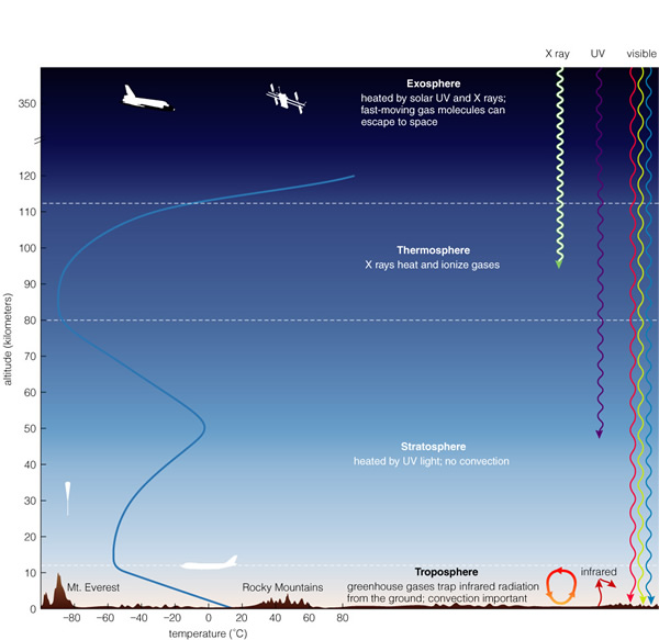
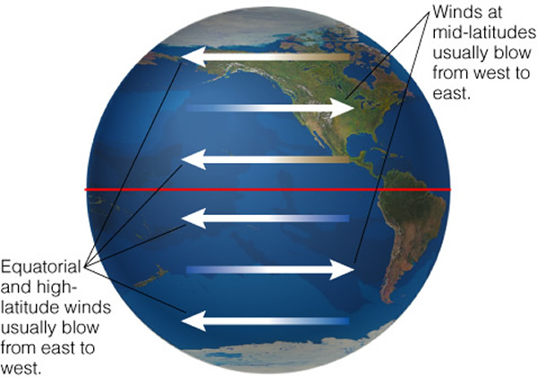
Just about all of the weather (and most of the clouds) are found in the troposphere, though cirrus clouds and large thunderstorms can reach to 30,000 ft (9 km) and higher. There are two kinds of major circulation patterns in our atmosphere, one is in a flow in longitude, the other in latitude:
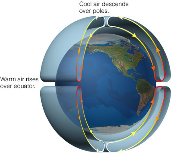
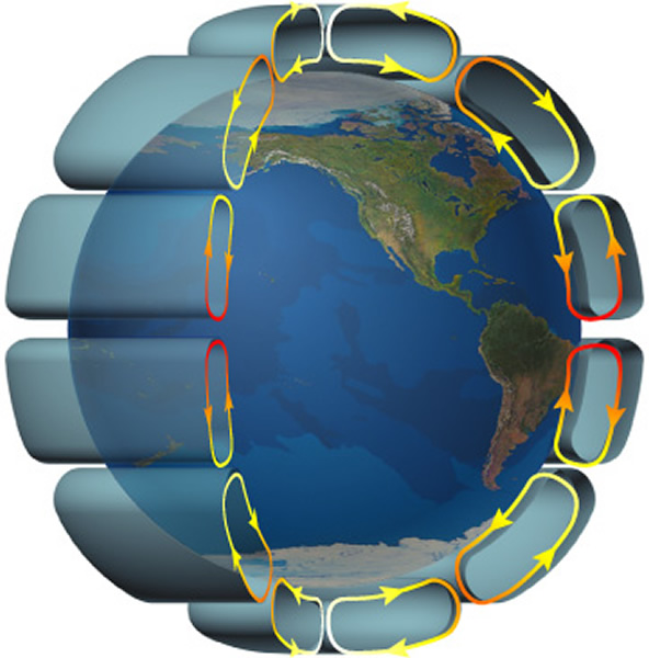
The increased heating at the equator, and the cooling at the poles, sets-up a circulation pattern to distribute the heat, but the Earth's rotation breaks this ciculation into smaller "cells":
What you are used to seeing on the weather report, however, is not the global circulation shown above, but smaller features---"highs and lows". These smaller-scale features are due to the "coriolis force" that arises due to the fact the Earth is spinning, like figure 10.14 from the book:

And this force causes the small scale rotation:
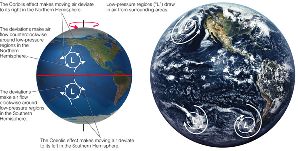
Air flows from high to low pressure areas, and the deflection to the right (in the northern hemisphere) cases the counterclockwise rotation of a low pressure (and a clockwise of a high pressure) system. Similar features are seen in the atmospheres of the other planets, it is just changes in scale and rotation speed that are the main differences. Note that the Earth's surface is kept warm by the Earth's atmosphere due to a process called the "greenhouse effect":
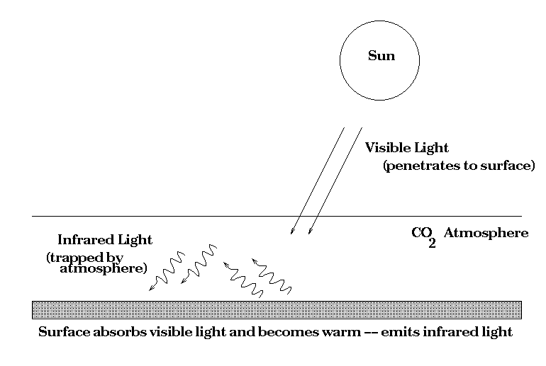
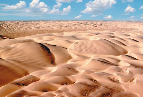
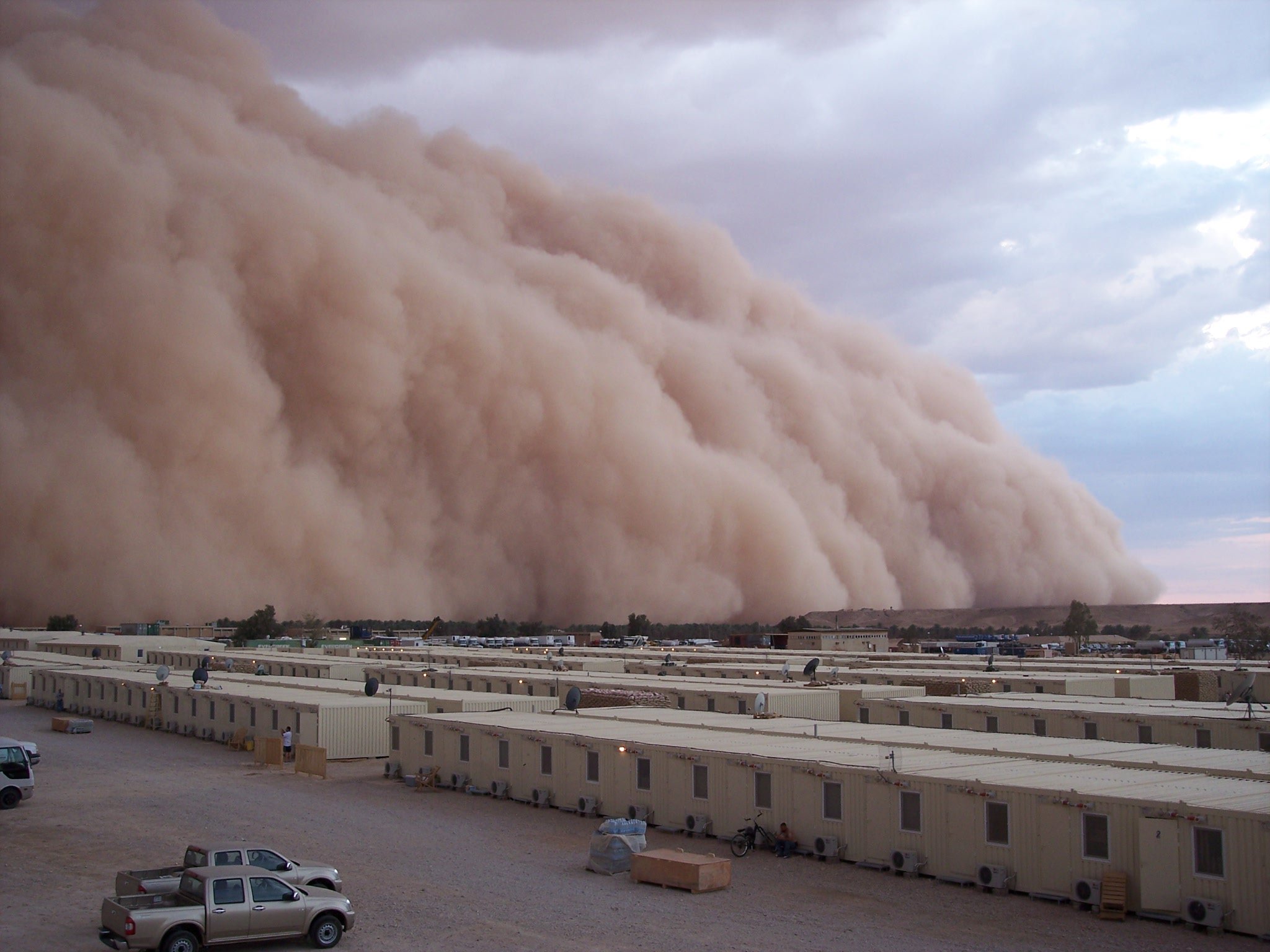
Infrared radiation is absorbed by water vapor, carbon dioxide and methane, and this "heat radiation" (more on this in a week or so) insures that the surface of the Earth is more pleasant than it would be without this warming. With an atmosphere to blow dust around and water to fall from the sky and dig valleys, the surface of the Earth is constantly being eroded-away. There are many complicated natural processes that help erode the surface, and this page lists the various weathering processes, including how chemical and living organisms assist in weathering rock (an excellent local example is White Sands--where rain falling in the San Andreas mountains leaches out gypsum, and this mineral-laden water flows into a lake where the water evaporates, and the wind picks up these minerals to make a dune field). All of these forces cause the nature of the Earth's surface to change over the eons since its birth. We will see this is not the case for the atmosphere-less Moon and Mercury, but we can find evidence for a similar variety of these affects on Mars, and for the actions of plate tectonics on Venus.
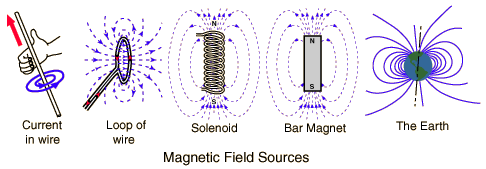
If you are a hiker, or a former boy/girl scout, you have probably used a compass--a little device that allows you to figure out the rough direction of the North (South) pole. How does this work? The Earth generates a magnetic field, and this field has two magnetic poles that are almost aligned with the North-South spin axis. The needle of a compass is a small magnet, and it tries to align itself with this external field.
But where does the magnetic field of the Earth come from? Because the molten core of the Earth is mostly made up of iron, it can carry an electric current. Just like an normal electric current:
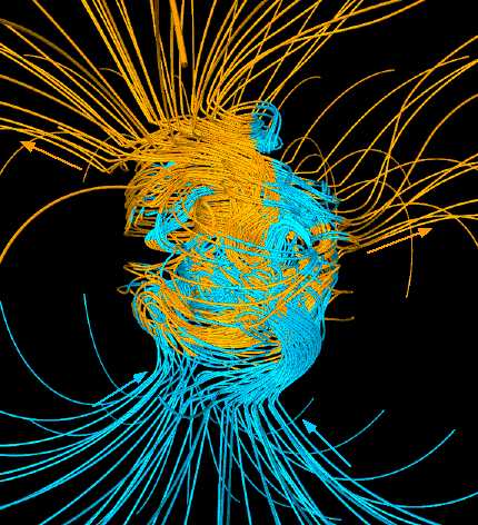
Because the core is rotating at different speeds in different places (differential rotation), the Earth's field is pretty messy:
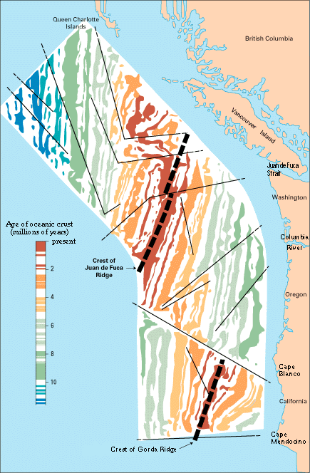
Due to this spinning, apparently, the magnetic field lines get twisted up to the point where too much magnetic energy has accumulated, and it has to be released. This appears to happen in the "field reversal" events (when what had been the orientation of magnetic north suddenly switches to magnetic south, and vice versa) that cause alternating stripes visible in some places on the ocean floor:
It is now believed that the magnetic field of the Earth is highly variable, and sometimes disappears, and sometimes the North and South magnetic poles switch positions! The time scale is long, but there is evidence that we are heading to a "pole reversal" , with possibly damaging effects.
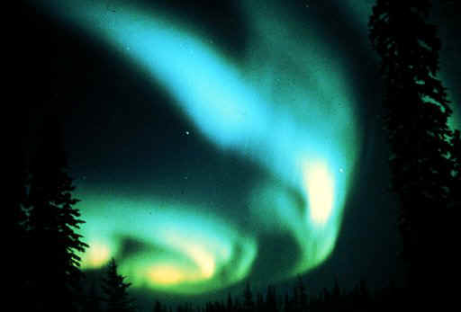
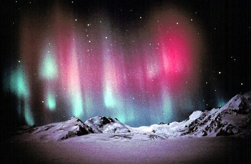
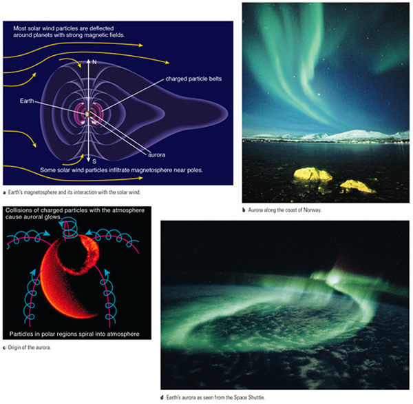
The Earth's magnetic field is also the cause of the Aurora Borealis. As high energy particles from the Sun sweep by the Earth, they are trapped in our magnetic field, and are forced down the field lines where they collide with the upper atmosphere to cause the aurora. When these particles collide with oxygen and nitrogen molecules the electrons in these molecules become excited, and emit red, blue, and green light:
The magnetic field of Earth extends well into space, and helps block "cosmic rays" emitted by the Sun that would do great damage to life on Earth:
We will see that most of the planets in the solar system have their own magnetic field. Some much stronger than the Earth's, some much weaker. Mars for example has almost no magnetic field at all---some believe that erosion of Mars' atmosphere by particles from the Sun is why the atmosphere on Mars is so thin, and why the planet has lost its water. But the presence of these fields is also an important probe on the internal structure of a planet, and we will encounter this subject again on our voyage through the solar system.
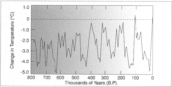
Throughout most of the Earth's history, there appear to have been wild swings in the mean temperature (note this is not the "global warming" that is much talked about at present--for a debate on that subject go here). The Earth's climate appears to alternate between ice ages, and warm periods (interglacial periods). The graph shown below tracks the Earth's temperature for the last 1 Myr:
The last 160,000 years are shown below, suggesting the last ice age ended about 15,000 yrs ago:
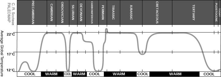
On the long-term, Earth's climate has gone through large temperature excursions:
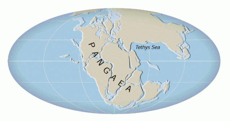
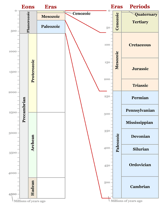
Evidence is mounting that some of the great climate changes experienced in the Earth's history may have been due to plate tectonics (go here for more on this topic, and here for a geological eras timeline). As noted above, some people had noticed all the way back in the 16th and 17th century (Ortelius and Bacon) that the continents sort of fit together in a supercontinent we now call "Pangea" (that occurred about 350 million years ago, in the Devonian/Carboniferous eras):
It was a person by the name of Alfred Wegener that really was the first champion of this theory within a scientific framework (and did he suffer abuse from his colleagues!). Besides noting how the continents fit together, he (and his contemporaries) noted certain patterns of fossils:
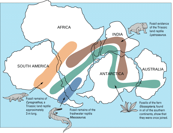
With the idea the continents could drift (continental drift animation), scientists have wondered if the locations of the continents triggered ice ages: "Two special conditions of terrestrial landmass distribution, when they exist concurrently, appear as a sort of common denominator for the occurrence of very long-term simultaneous declines in both global temperature and atmospheric carbon dioxide (CO2):
1) the existence of a continuous continental landmass stretching from pole to pole, restricting free circulation of polar and tropical waters, and
2) the existence of a large (south) polar landmass capable of supporting thick glacial ice accumulations.
These special conditions existed during the Carboniferous Period, as they do today in our present Quaternary Period1".
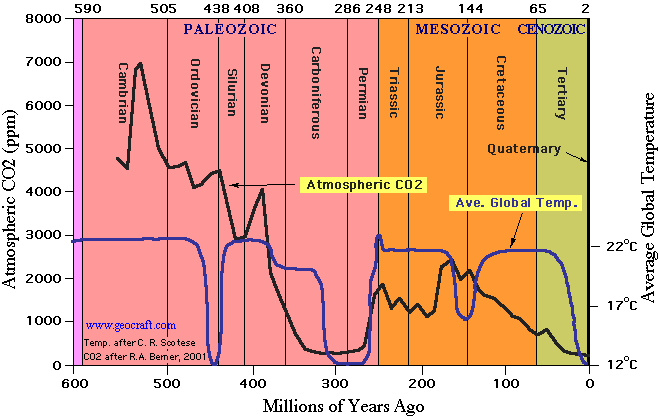
Here is a record of the carbon dioxide content of our atmosphere plotted along with the global mean temperature:
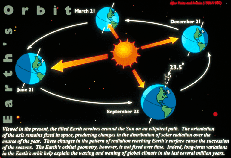
Other causes of ice ages may be from changes in the geometry of the illumination of the Earth by the Sun. For example, the current geometry, and the cause of the seasons is due to the tilt of the Earth's rotation axis with respect to the plane of its orbit:
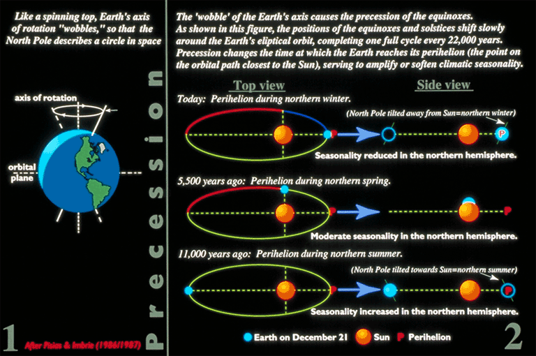
Like a top, the Earth's rotational axis wobbles, tracing out a circle in space with a 22,000 year period, this phenomenon is known as "precession" (like this top). Because of precession, however, the nature of the seasons change slowly due to a constantly changing orientation of the northern and southern hemispheres of the Earth with respect to the in-coming solar illumination:
The wobble of the Earth's axis causes the amount of sunlight at all latitudes to vary (~30%). Here is a plot of the "insolation" at 65o:
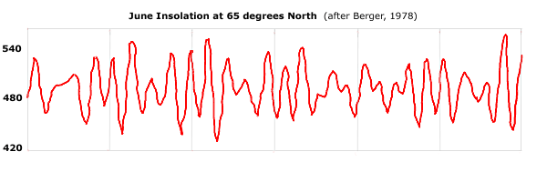
While it is believed that these affects alone are insufficient to drive the major glaciation events, it is possible that the change in intensity of these events are the source of the milder and colder periods that seem to occur on 40,000 to 100,000 year time scales (the major glaciation events occur on millions of year time scales). The actual precession of the Earth's spin axis is stabilized by the presence of the Moon--keeping it from large excursions. Mars does not have such a stabilizing body, and hence it exhibits huge changes in the inclination of its spin axis--the result is extreme climate swings (on millions of years scales). Large volcanic eruptions, or asteroid/comet impacts (more about these later!) with the Earth might also cause ice ages due to the dramatic cooling caused by the cloud of dust that is raised. One or the other may have been the cause of the great "dinosaur extinction" event that leads to the rise of mammals, and to the evolution of humans.
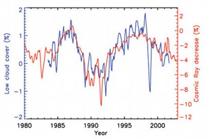
Interestingly, evidence is starting to mount that smaller swings in our climate maybe due to changing levels of solar activity. As we will discuss in a few weeks, the Sun has an 11 year cycle where it swings between a large number of magnetic storms ("solar maximum"), and periods with much less activity ("solar minima"). During solar maximum the Sun's "magnetosphere" (the region where its magnetic field dominates) expands, during minima it contracts. Swarming through all of space are high energy particles called "galactic cosmic rays". When the Sun is at maximum, most of these charged particles are deflected away from the Earth. At minimum, however, many more penetrate our atmosphere. New research shows that an increased cosmic ray flux causes more clouds to form in the Earth's atmosphere:
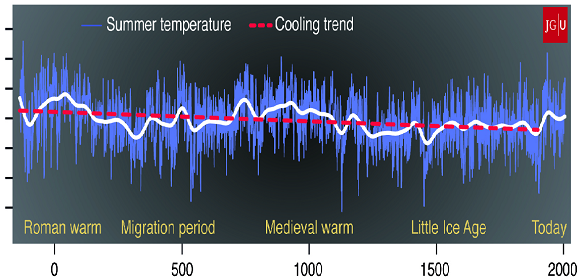
Going further in the past, we also see evidence that the cosmic ray flux may have caused the most recent climate anomalies (the medieval warm period, and the "little ice age"):
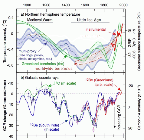
Here is a new reconstruction of the temperature history of the northern
hemisphere over the last 2,000 years showing that there have been warm periods, and
cold periods. There is nothing here that suggests the current climate is unusual
(though, unfortunately, such a statement remains controversial).